Image

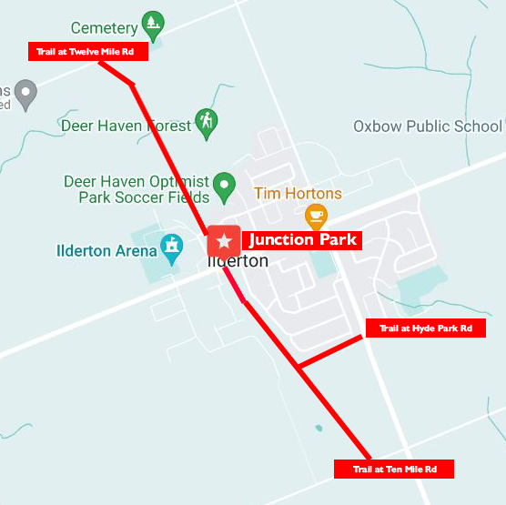
The Ilderton Rail Trail starts at Junction Park on Ilderton Road.
To the north, it goes along through Deerhaven Optimist Park to Twelve Mile Road.
To the south, it follows behind the homes and into a forested section, where it splits and goes south to Ten Mile Road and east to the Ilderton Fire Station on Hyde Park Road.
- Trail Map
- Trail Sections / Detail
-
Trail Section Distance (approximate) Surface Environment Junction Park to Twelve Mile Road
(north of Ilderton Road)1,470m (4,800ft) Unpaved Level ground Urban, parkland, and fields
Junction Park to Split
(south of Ilderton Road)770m (2,500ft) Paved Level ground Urban and forest
Spilt to Ilderton Fire Station
(south of Ilderton Road)450m (1,450ft) Paved Level ground Forest and fields
Split to Ten Mile Road
(south of Ilderton Road)740m (2,400ft) Unpaved Level ground Forest and fields
- About the Trail
-
- Part of the Ilderton Rail Trail is including in Middlesex Centre's Paws in Parks program. Dogs are permitted to be off-leash in marked sections only, and must always be under their owner's control. See Paws in Parks for more information.
- The Ilderton Rail Trail features one of Middlesex County Library's Storybook Trails. The storybook trail is accessed from behind the fire station (Heritage Drive).
- The paved portion of the trail is maintained over the winter as staffing and weather allow. Roads, sidewalks and municipal facilities receive snow clearing priority.
Type
Trail
Community
Ilderton
Address
Entrance at Junction Park
13235 Ilderton Rd
Ilderton ON N0M 2A0
Canada
